 update (February 26, 2010): I may have passed this “Begin” sign many times, but never noticed it until I was pacing the block across from the Grog Shoppe on February 8, while waiting for a late Amtrak train to arrive. It seemed strange to encounter the End Scenic Byway sign last year, but this view of where the Byway begins is even more telling.
– you can share this posting with this shorter URL: http://tinyurl.com/SchdyByway
original posting (with March 27, 2014 update)”
 Last weekend, we asked if anyone could help explain this sign marking the “End” of the Mohawk Towpath Scenic Byway, on the block of Erie Blvd. between Liberty and State Streets, near The Grog Shoppe (Google map). Since no one came to our assistance, we did a little research of our own. The U.S. Department of Transportation’s “America’s Byways” webpage for the 27.7-mile Mohawk Towpath Byway [map] invites you to:
“Visit New York’s historic canal system and see the locks and bridges that made canal transport possible for almost two centuries. The Mohawk Towpath Byway links scenic, recreational and historic resources. Architecture from the 18th and 19th Centuries endures, as does the landscape and the perseverance of the canal builders.”
. . . in case you’re wondering what the stretch of “scenic byway” leading up to our sign looks like, here’s the view, looking northward:

– that’s the scenic and historic Burger King at Liberty St. and Erie Blvd. –
. . . and across the street (the Schenectady Amtrak Station):

According to the Wikipedia entry for “Mohawk Towpath Byway,” it was “Built on local grass roots enthusiasm” and “is a series of local, county, and state highways between Waterford and Cohoes and Schenectady along the Mohawk River and historic Erie Canal in upstate New York.” For more details, see “Mohawk Towpath Scenic Byway Overview,” from the U.S. DOT’s America’s Byways site, and the Mohawk Towpath Weblog.
. . . also, click for a collection of “best bets” to see along the byway, compiled by the not-for-profit MTSB Coalition. Remarkably, the above stretch of Erie Blvd. did not make the “best scenic views” list. If you’d nonetheless like to acquire a shirt or mug boasting the MTSB mule logo, go to their store.
.
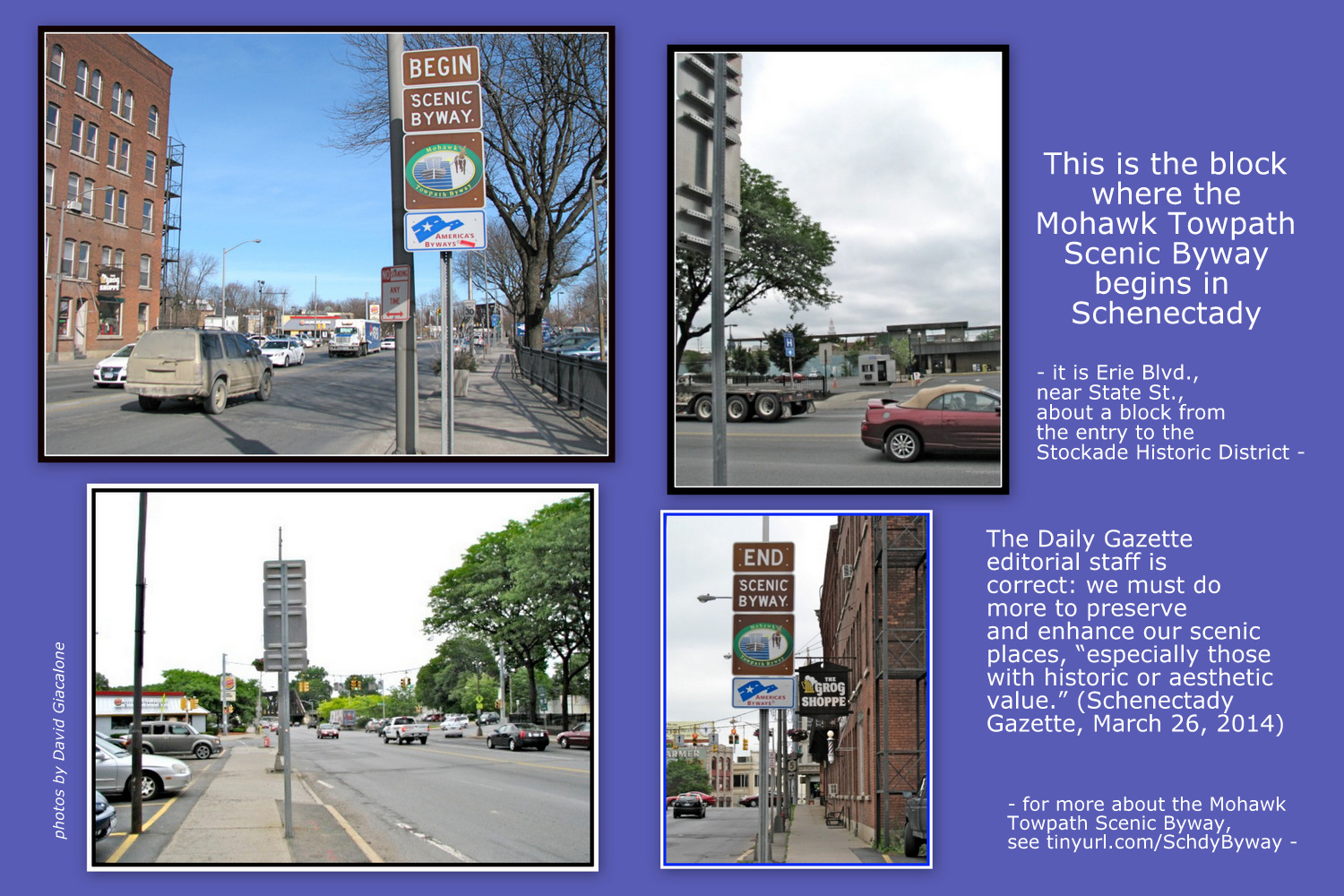
follow-up (March 27, 2014): The Schenectady Gazette had an editorial yesterday titled, “Protect Mohawk scenic byway.” (March 26, 2014, C7) I put together the collage above to highlight the importance of their cause — preserving our scenic places, “especially in places with historic and aesthetic value. They’re keys to protecting quality of life and attracting tourist dollars”. The editorial staff is correct that “The plan needs to be officially endorsed and incorporated into the planning and zoning laws of the eight communities that are part of the byway coalition.”
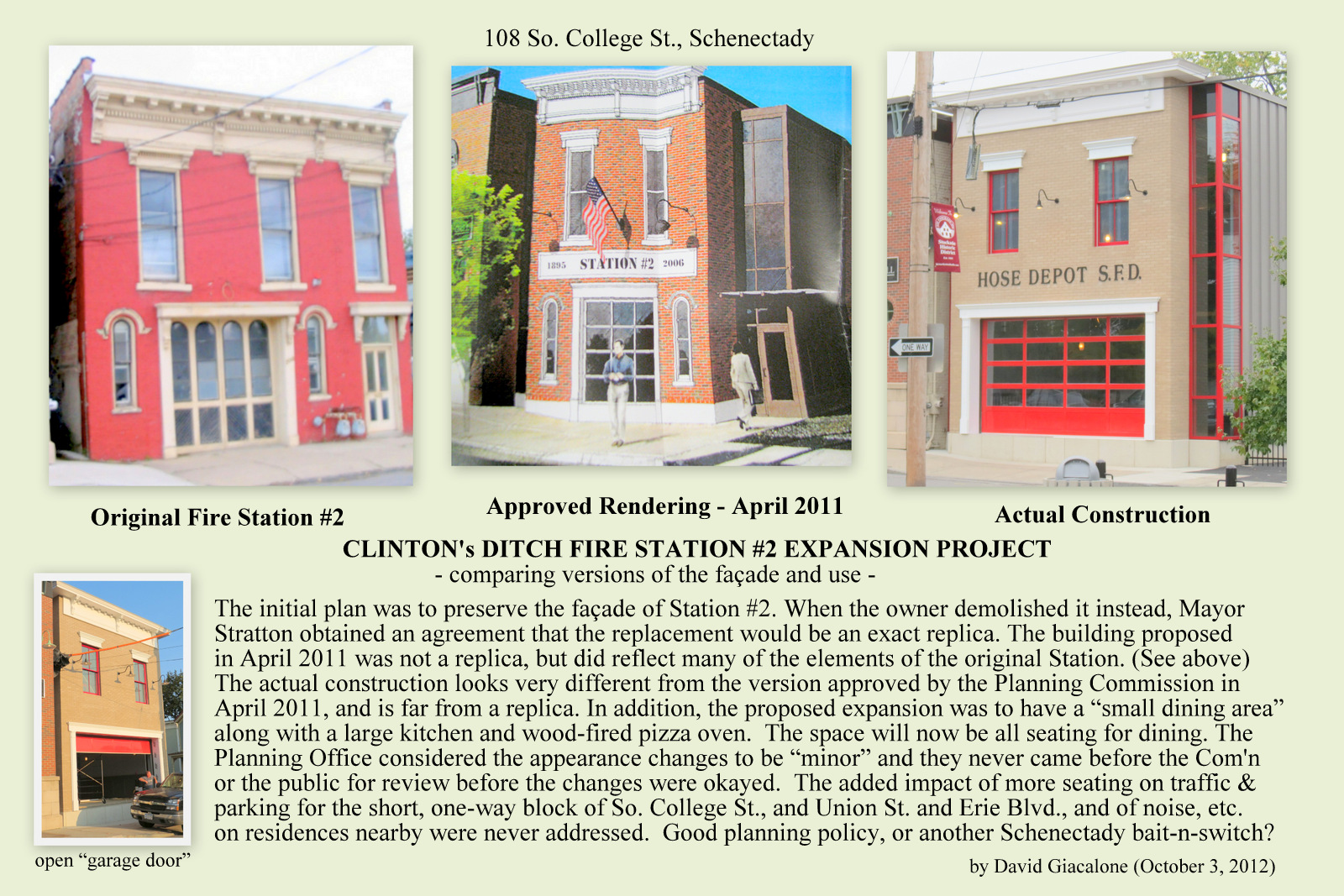 Click on the collage at the head of this paragraph. It concerns a location along the Byway, on S. College Street,just a block and a half from the “Begins” sign. The City’s historic Fire Station #2 was torn down without permission by a property owner, who then promised to build a replica, which would be part of the Clinton’s Ditch Restaurant facility. The so-called replica fire station ended up looking like an auto mechanic shop or a storage warehouse. And, the final design was never even presented to the public before approval. The episode is proof that the Schenectady Planning Board often gives virtually no weight to history or aesthetic values. Sadly, it will probably take a lot more than editorials to get it to change its ways.

The western terminus of the Mohawk Towpath National Scenic Byway is at the intersection of Erie Blvd and State Street in Schenectady. The Byway is a series of local, county, and state highways that follow the historic route of the Erie Canal between Schenectady and Waterford that tells the story of the waterway west and the role our communities played in the westward expansion of the country and in the Industrial Revolution.
Erie Blvd in this area was formed when the Erie Canal (1825 to 1917) was abandoned and filled. Canal traffic since 1917 uses the Mohawk River in as it passes Schenectady.
Follow these signs north out of the city and discover the rest of the Mohawk Towpath Byway.
By: Eric Hamilton on June 12, 2009
at 2:50 pm
Thank you for the additional information, Eric.
By: dgiacalone on June 12, 2009
at 5:30 pm
David:
Thank you for your full and balanced evaluation at of the Mohawk Towpath Byway. Your comments and pictures are especially well timed as we look at scenic conservation issues along the Byway corridor this year. Further, I would like to invite you to become a friend of the Mohawk Towpath Byway by visiting http://www.linkedin.com/groups?about=&gid=1352327&trk=anet_ug_grppro
Finally, I like the appropriate name of your blog! Edmonds’ “Drums Along the Mohawk” has been a great summer read.
By: Eric Hamilton on July 25, 2009
at 2:36 pm
Thanks again for your positive words about our coverage of the MTB, Eric. As you surely noticed, I tried to tell folks important info about the Byway while keeping my gadfly tongue in cheek.
Although I appreciate the gesture, I’m very allergic to being on any web group lists, so I’m going to decline your offer to become a Friend of MTB. Please feel free to let me know of Byway news that might be of interest to folks here in the Stockade.
By: David Giacalone on July 26, 2009
at 8:56 am
[…] Grog Shoppe with the sign announcing the “end” of the Mohawk Towpath Scenic Byway (see our posting) — which is to say, I was again unsure about the meaning of the sign, which shows a stylized […]
By: new signs lead to the Erie Canalway Trail « suns along the Mohawk on August 20, 2010
at 11:36 am