 In the posting “help stop the Riverside Park dock” (April 18, 2010), which also has many photos of the beautiful Park and its scenic vistas, I described the reasons why I and like-minded folks oppose the proposal to put an unsupervised 300′ public dock parallel to the riverbank, along the Mohawk River at Riverside Park. In this posting, you will find photos that “show” (rather than “tell”) why we believe the dock has the potential for significant adverse environmental effects on Riverside Park’s treasured scenic views and ambiance, on the leisurely activities enjoyed by its users, and on the quality of life of nearby Stockade residents.
 Our State environmental review laws [SEQR] include effects on “resources of . . . historic or aesthetic significance” and on “existing community or neighborhood character” in the definition of environment. [§617.2(l)] We believe that the potential for significant environmental harm is great enough to warrant a full environmental review by the City of Schenectady before the dock is approved. There have been some indications that the City will instead issue a “Negative Declaration” under SEQR in the near future, ending all review — and formal public participation concerning environmental issues — without the preparation of an Environmental Impact Statement.
 Note: For a comprehensive set of Comments to the City on the need for full SEQR environmental review of the Dock, click here (dated Oct. 1, 2010, 13 pp. pdf.); and, see a Schenectady Gazette OpEd column (Oct. 3, 2010, D1), both by David Giacalone. Also, see the Stockade Association letter to the Schenectady City Council requesting full SEQR environmental review (Sept. 28, 2010). . . to share this posting you can use the short URL http://tinyurl.com/DockSEQR

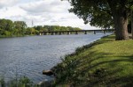
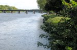
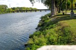
– site of the proposed 300′ dock (parallel to the riverbank, between North St. and the Esplanade at N. Ferry St.) as seen from Scotia –
– Click for a copy of the plat of the Riverside Dock Construction Plan, which was included last month in the Planning Office’s draft Economic Assessment Form. (Note: Because the City’s copy is so faint, I have outlined important items and relabeled them to make them legible.)
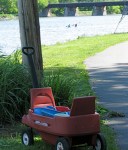
Immediately below is a Slideshow of photos (which appear in random order) that “show” why we are concerned about the impact of the dock on the Park, its current users, and its neighbors. Below the Slideshow is a Gallery that you may use to view larger versions of any of the images.
.
.
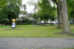
Scroll over each thumbnail in the Gallery below for a description of the scene and click on a photo for a larger version. The photographs with captions were taken to depict views from or toward the proposed site of the dock; to show the proximity of homes to the Park, dock or parking areas; or to point out the narrow one-lane streets used for access to Riverside Park. Photos without captions capture some of the ways folks enjoy Riverside Park and its stretch of the Mohawk River.
– below the Gallery are larger versions of select photos –

.
– Suggestion: when viewing the photos, ask yourself questions like:
- how would the dock change the view from here?
- how will the dock (and the people/activities it brings) affect people living nearby?
- how would the dock affect the way Riverside Park has been and will be used?
-
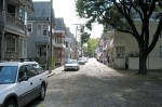
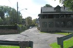
- traffic in both directions must use this one lane on Ingersoll Ave.


-
- traffic in both directions must use this one lane on Washington Ave.
-
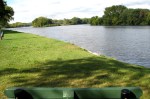
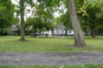
- view east from riverbank near basketball courts

-
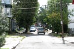
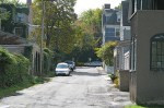
- traffic in both directions must use this one lane on No. Ferry St.
-

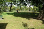
- sidewalk chalk fun

-
- view east from the end of Washington Ave.


-
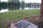
- view from east end of dock to 28 Front St. (200′)
-
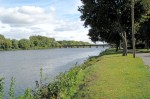
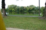
- view east from the Esplanade
-
- view west from bank near the tennis courts
-
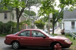
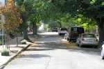
- North St. homes and a small parking area & turn-around border Riverside Park


-
- Governor’s Lane homes and a small parking area & turn-around border Riverside Park

-
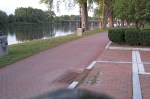
- view west from bench at Ingersoll Ave.
-
- view from the cannon on the Esplanade near N. Ferry St.

-
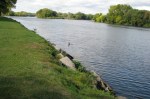
- view east from riverbank near North St. (at east end of the dock)
-
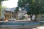
- Ingersoll Ave. homes and a small parking area & turn-around border Riverside Park


-
- view north from alongside 31 North St. – 200′ from riverbank
-
- view west from riverbank near North St. (east end of proposed dock)
-
- view east from bank near Governor’s Lane
-
- view north from alongside 28 North St. – 200′ from riverbank
-
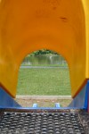
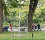
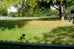
- view from top of slide to site of proposed dock 21 yards away


-
- view from dock to North St. residences 200′ away
-
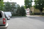
- North Ferry St. homes and a small parking area & turn-around border Riverside Park
-
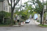
- North St. is 15 ‘6″ wide and traffic in both directions must use this one lane


-
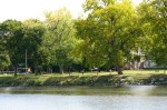
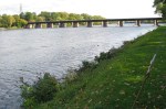
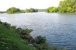
- site of the proposed parallel dock seen from the Mohawk River


-

- view from the bench near the basketball courts

-
- view from swingset of the site of the proposed dock
-
- view east from near midsection of the proposed dock
-
- traffic in both directions must use this one lane on Governor’s Lane
. . another look:

view from a bench near Ingersoll Ave.
. .

.
 . .
. .
.

..
.

view from swingset of the site of the proposed dock
.
 . . . .
.

.

view east from riverbank near basketball courts
.
 . .
. .
.

.

Ingersoll Ave. homes and a small parking area border Riverside Park
. . 
.

.

view from the cannon on the Esplanade near N. Ferry St.
.

.

.

.
 - 29Sep2010")
- view from top of slide to site of proposed dock
 - 29Sep2010")
.
 . . .
. . .

.

. . . 
 . .
. .

.

- view east from bank near Governor’s Lane

. . . 
.
. . . 
.

I think a dock would be a wonderful addition to the Riverside Park area of Schenectady.
By: Bill Frank on October 3, 2010
at 10:00 am
This quiet residential park, as well as the overly polluted river, does not need a new dock for motor boats, 10 new parking spaces, a kiosk, and a new fire/police boat; however, some ghats would be grand.
By: T Hodgkins on October 7, 2010
at 1:45 pm