 . . Editor’s Note: This posting has grown quite large, with many updates, as I learned more and more about the Western Gateway Bridge [“WGB”], the regulations and process at NYS Department of Transportation [“DOT”], and the actions and non-action of our local municipal leaders and planners. At first, I focused solely on the beautiful view lost when steel railing was replaced by a cement parapet, but as I learned more about the threat posed by the barrier-less sidewalks, I came to believe the Sidewalk Safety Issue was just as important and surely more urgent. Click on the collage image to the right of this Note for a larger version of a 1-page flier summarizing the Lost View & Sidewalk Safety issues at the Western Gateway Bridge, over the Mohawk River, NY Rte. 5, between Schenectady and Scotia NY.
You can get a crash course on the issues raised by the $16.9 million WGB rehab project by reading the two following documents:
 Click this link to go directly to a section that focuses on the Sidewalk Safety Issue
 . . .
. . . 
.
new Rexford Bridge – Gaz.
follow-up (May 2018): Our WGB safety-beauty campaign got no help from any of our local leaders, nor from the Stockade Association. The only success was preserving the less impressive eastward view from the Bridge, with thanks to a Gazette Editorial, described below. However, our efforts might have sensitized NYS DOT, as well as local pols and users of the old Rexford Bridge down the River. As you can see from a Gazette photo, by Marc Schultz, when the Rexford Bridge opened in November 2017, see-through steel railing on the bridge permits a view westward along the Mohawk River, and the shared-use sidewalk is both raised and protected by guardrails.
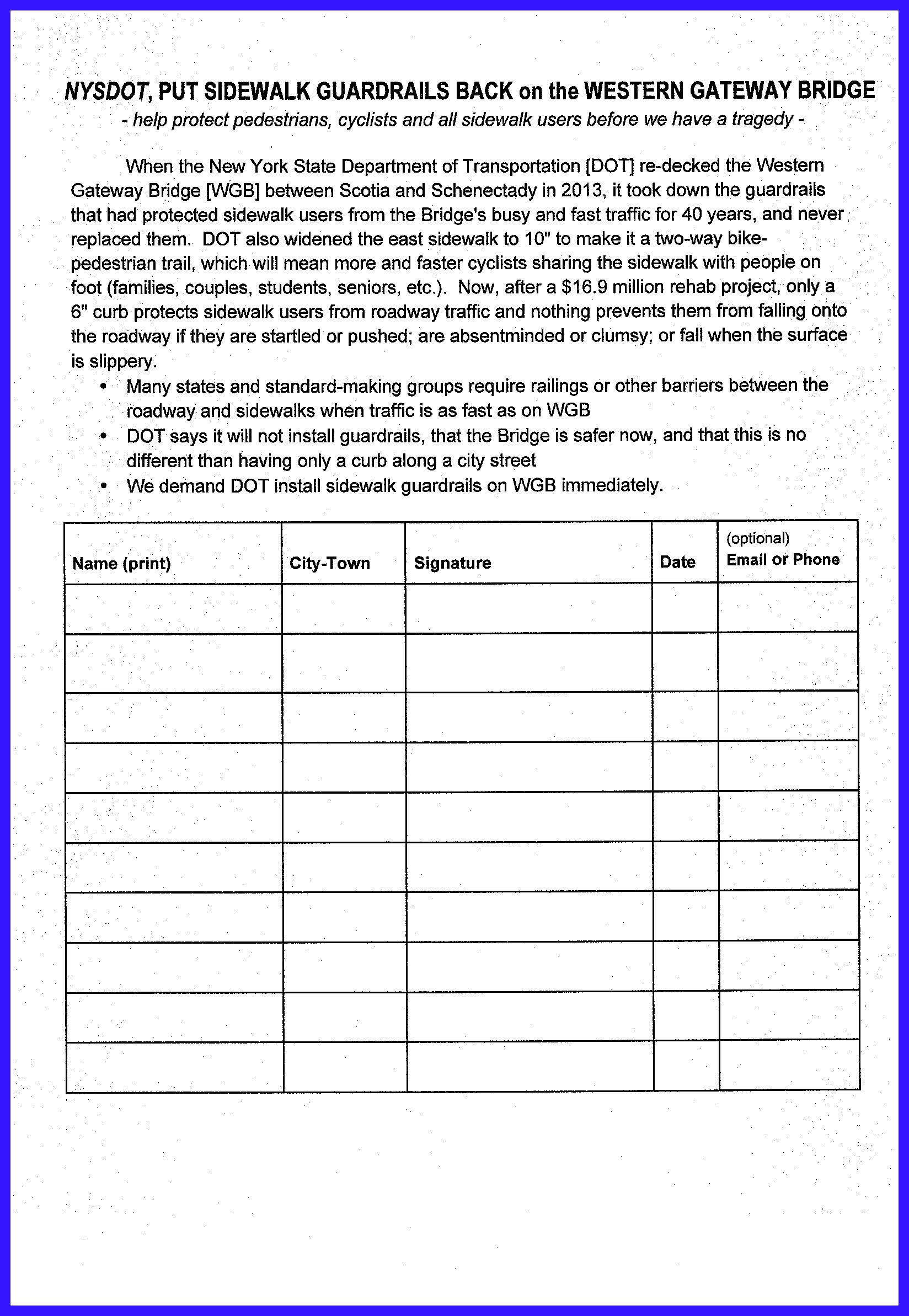
Go here to learn about our [closed] WGB Guardrails Petition. . 
– to share this posting, use this short URL: http://tinyurl.com/WGBissues
.
Original Posting (with updates, follow-ups, etc.)
 03Oct2013")
– the above collage shows the lost views and some of the problems caused by the cement wall parapet; click on it or any photo in this posting, for a larger version –
“Take down that wall, 
. . . and put up sidewalk guardrails!”
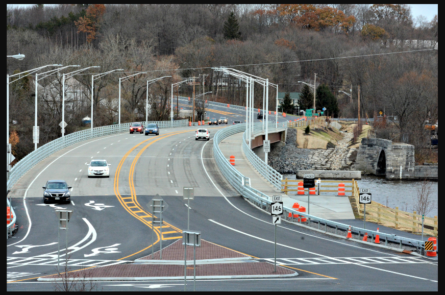
There is a lot of misinformation about how that cement wall (parapet) that steals our views of the Mohawk River ended up on the Western Gateway Bridge (Google map). This posting attempts to set the record straight, using readily-available public records (primarily from the webpage for the NYS Department of Transportation [“DOT”] Accelerated Bridge Program, Phase 1B Zon 1 Contract). I hope you will be motivated to let your local leaders and Legislative representatives know you want your scenic treasure back, along with guardrails to protect pedestrians and bicyclists from fast-moving traffic that jumps or rolls over the curb or — more likely — that they fall into by accident or are forced into when interacting with other sidewalk users.
 The cement wall built by Kubricky Construction Corp. on the west side of the Western Gateway Bridge [WGB] robs us of beautiful views of the Mohawk River. Despite excuses given now by local officials (including Scotia Mayor Kris Kastberg), the wall did not happen because the contractor has full authority to design the bridge on its own under its design-build contract. The NYS Department of Transportation [DOT] sets requirements and reviews design proposals and changes even for design-build projects. It does not hand a contractor a large check and a blank sheet of drafting paper. In fact:
- DOT Required the Cement Wall Months Before the Contract was Awarded. DOT mandated the cement wall as early as May 2012, during the bidding process, three months before Kubricky was awarded its contract. See Addendum No. 4 and Addendum No. 5 to the Project Requirements document. Our local leaders did nothing to stop the wall or even alert the public so that we could voice our views about the loss of a treasured scenic resource.
- We Gained Bike Lanes and Lost Scenic Vistas & Guardrails: The original Project Requirements announced on April 11, 2012 required a (see-through) four-rail steel railing. Our local newspaper and others immediately asked why there were no shared-use lanes and no mixed use bike-pedestrian pathway. In response, on May 11, 2012, at the same time it changed the bridge requirements to create two multi-use lanes and a wider path for pedestrians and bicyclists, DOT amended its plan to instead require a cement wall and barred the 4-steel-rail alternative; it also said that no bicycle fencing need be placed above the parapet to prevent bicyclists or pedestrians falling off the bridge. The issue of pedestrian guardrails was not mentioned in either the original or modified bridge requirement memos.
Did the community forfeit its scenic view by asking that the bridge be safer for bicyclists & pedestrians?. If that were the tradeoff, due to fiscal or engineering requirements, DOT surely discussed it with our local leaders while they were engaged in an active dialogue about including the multi-use lanes and bicycle-pedestrian pathway. In his letter to me dated October 15, 2013, Schenectady Mayor Gary McCarthy rejected the tradeoff explanation, saying “I believe it was simply a project decision based on the experience and preferences of the designers.”
 DOT has also said the multi-use changes were not the cause, and I think we have to take the agency at its word. DOT spokesman Bryan Viggiani told a Gazette reporter in an email: “In conjunction with the change [adding the multi-use lanes and path] the decision was made to make the barrier decorative, rather than the standard four-beam steel bridge railing. Local leaders were not made aware of the change in barrier plans at the time, he said.” (“Western Gateway Bridge has roots in early 1800s“, Sunday Gazette, by Kelly De La Rocha, November 3, 2013; also see Gazette editorial, “DOT must do more about lost bridge view“, September 12, 2013).
For most of us, it is surprising that DOT believed a “decorative cement barrier” was an aesthetic improvement over standard beam railing that allowed a beautiful view of river and forest, or that a cement parapet was a better option than merely using more attractive steel railing. Nevertheless, the fact that the switch was seen as a decorative-aesthetic bonus, rather than a cost-cutting or safety measure, indicates that an early public outcry over losing the view might very well have received a positive response from DOT. l had originally thought that the switch to the cement parapet was probably a fiscal or engineering and safety tradeoff due to the incorporation of multi-use lanes. That is apparently not the case. For example, the Bridge’s new configuration, with the wider multi-use lanes, did not require a wider deck; instead, the deck is actually four inches narrower than before the multi-use lanes were part of the design.
Because the switch was instead due to an aesthetic judgment that clashes greatly with the feelings of the community, I also believe continued advocacy to salvage the beautiful western view may be effective, especially when coupled with the need to better protect sidewalk users. Dollars and delay seem a comparatively small price compared to restoring a rare scenic view from an urban bridge and traditional sidewalk safety measures.
 Local Leaders Should Have Known and Acted. The documents requiring the cement wall, plus a sample photo of a cement wall, were immediately posted at the DOT site in mid-May 2012. County, City and Town officials should have been monitoring this important, $18.1 million project for such changes. Whether or not there were formal communications between DOT and local jurisdictions, our local leaders were sufficiently “in the loop” to know in April 2012 that the original configuration had no new multi-use lanes, and then, in Mid-May 2012, to tout their role in convincing DOT to add the requested lanes and bike path.
Local officials tell us now that DOT never directly told them about the change and they never thought to ask about railings and parapet barriers. But, such monitoring should have been an obvious obligation for “planners” and representatives of local residents.
Indeed, DOT advises at its Accelerated Bridge Program [ABP] information portal: “Visitors are urged to check the website regularly, since changes are possible.” The agency makes that task quick and easy to accomplish through its ABP webpages. Their informative website was surely implemented so that “stakeholders” in all sectors could keep informed about the process and progress of a particular project.
An Important and Obvious Lesson: Design-build transportation projects call for more, not less, monitoring against safety, aesthetic and environmental threats. The lack of public participation in the process is not an excuse for local officials to do nothing; it should instead make local officials, especially planning officers, more alert to changes in order to protect the public interest. That is especially true because DOT has customarily shown a willingness to listen and respond in positive ways to community concerns and preferences.
 The public deserves to know who knew about the substitution of a cement wall, and also about the decision to eliminate sidewalk guardrail protection, but decided they were acceptable and/or not something they need tell the public. If somehow our planners and leaders were oblivious to the loss of vistas and guardrails, we need to know who failed to find out that crucial information and why.
- The View Eastward is Saved: The DOT decisions about the eastern edge of the Bridge are instructive. As with the western side of the WGB, DOT first required a four-rail steel railing but then changed to a cement parapet in May 2012. However, on September 8, 2013, within a few days of a public outcry and Gazette editorial about the cement wall and loss of scenic views, DOT announced that the eastern view will be preserved by installing a steel railing rather than the cement wall; the cement wall would, nonetheless, remain on the west side of the bridge. (see Daily Gazette, “View from Western Gateway Bridge partly preserved”, Sept. 9, 2013).
 The speed of this concession clearly shows that DOT has no concerns that providing a scenic view is somehow a safety hazard, which is a specious argument being made now by some local officials and apologists. In addition, DOT’s claim that the see-through railing is being provided on that side to give a better view to bicyclists and pedestrians makes no sense: bicyclists and pedestrians (all except the tiniest) can readily see over the cement wall; it is drivers and passengers in conventional vehicles who cannot. Clearly, the community’s complaints led DOT to salvage the eastern views of the Mohawk. (See Gazette editorial, “DOT must do more about lost bridge view”, September 12, 2013) Such responsiveness is admirable and underscores the need for earlier and continuous community input, through public comment periods or the vigilance of local officials.
- (Dec. 13, 2013) No Good Reason for the Redesign to Leave Out the Guardrails: The lane from Schenectady to Scotia is still being constructed going well into December 2013. When the plans for WGB were redesigned in September to include the steel railing that would preserve the eastern view, it should have been obvious and easy to also include a separator guardrail between the sidewalk and the roadway. Many members of the public asked for this safety measure, and our local leaders should have been making the argument that without guardrails those using the sidewalk would be in more danger than with the pre-rehab configuration of the Bridge. Unfortunately, DOT seems to be arguing that the old guardrails were there to protect vehicles, by reducing the number or severity of collisions with the outer railing. The protection of pedestrians and bicyclists was an unintended benefit of the guardrails, is their apparent argument, so that losing that protection is not an important design issue for the project. DOT made that argument earlier this year about a bridge in Troy. See the Times Union Advocate column for June 6, 2013..
update (Oct. 15, 2013): Click this link to see Schenectady Mayor Gary McCarthy’s response to my email letter summarizing the major points in this webposting about the Bridge, and click here for my reply
- Take Pittsfield’s Example. In 1996, Mass. DOT built a retaining wall as long as the WGB wall that blocked the view of Pontoosuc Lake. Citizens, the Pittsfield City Council, and other leaders demanded the State tear it down and replace it with a structure that would save the view, and they succeeded. (See, e.g., Boston Globe)

WE MUST ACT NOW. With the bridge scheduled to be completed by December 31, we must let our local and County leaders and our Legislative representatives, as well as DOT, know that we want our scenic views back. [At the bottom of this posting is a more comprehensive description of what I have learned about the WGB rehabilitation project, with quotes from relevant documents.]
– share this posting with this URL: http://tinyurl.com/WGBissues
Some relevant email addresses:
Farley@nysenate.gov; tkaczyk@nysenate.gov; SantabarbaraA@assembly.state.ny.us; SteckP@assembly.state.ny.us, tediscj@assembly.state.ny.us;
 Manager@schenectadycounty.com; legislature@schenectadycounty.com; RGillen@schenectadymetroplex.org; KJohn113@aol.com [Karen Johnson County Legislator]; gmccarthy@schenectadyny.gov; mcking43@aol.com [Peggy King]; ckoetzle@townofglenville.org
Also: Sam Zhou, P.E., Director, Region 1, NYS DOT; 50 Wolf Road, Rm 1s50; Albany, NY 12232; phone: (518) 457-3522; director’s secretary: tracy.kuc@dot.ny.gov
- Cong. Paul Tonko: phone his Washington DC office [202-225-5076] , or his main district office [518-465-0700] and/or email the Congressman using his website email form.
Read More…
 . . .
. . . 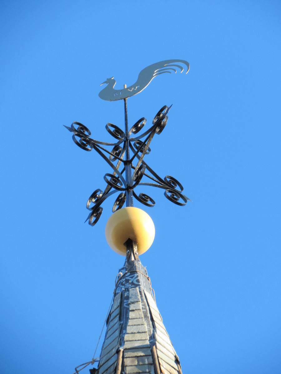
 update (December 1, 2013): We’ve added a few more photos showing the completed copper flashing and shingles, etc., on the steeple. Read about it in the Schenectady Gazette, “St. George’s restores its crowning glory: Restoration work on the steeple at St. George’s Episcopal Church has been completed” (Nov. 30, 2013, by Jeff Wilkin; online subscription req’d); and see the December 2013 Stockade Spy at 12.
 new [L] and old weathercocks, plus Andy K.
 After five months without its weathercock, St. George’s steeple had its weathervane re-installed on November 20, 2013. The beautiful old rooster was too deteriorated to be refurbished, and was instead replaced with a replica made of copper, by Lou Venditti of Specialized Sheet Metal, and painted a golden color. Its decorative ball also had to be replaced and is constructed of Sapele wood. The scrollwork and pointer were welded, stripped and repainted by Tom Madelone. A major contractor was steeplejack Dave Knox of Advance Construction and Steeplejacks. Robert A. Petito, Jr., AIA, was the project architect and Dan Kennison did overall supervision. As the project’s structural engineer, Jack Healy of Ryan Biggs Associates assessed the condition of the steeple and designed the steel replacement support for the weathervane assembly.
 For more on the weathervane and other aspects of the steeple repair, see the 27-page “St. George’s Steeple Project Report“, and especially David Kennison’s article “St. George’s Historic Weathercock” in the Episcopal Education column of St. George’s September 2013 Newsletter, at 8-9. After much research, Kennison believes the initials “MW” or “MWp” on the weathercock are those of the original blacksmith, Myndert Wemple, with the smaller “p” being an homage to his grandfather, whose nickname was “Post” or “Poest”.
")


 . . . Ed Salvo’s back for #34!


 03Oct2013")


Recent Comments